Browse Items (4998 total)
Sort by:
Lofalot, Worthington, Mass.
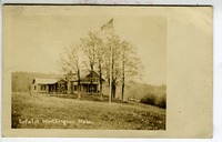
Scan only of sepia real photo postcard. Front: 'Lofalot, Worthington, Mass.' shows house on hillside with flag flying from tall flagpole. Divided back, Azo stamp box. Not mailed, but written on. Publisher unidentified. Message: Dear Atta? (Alta?),…
Logged Spruce Plantation
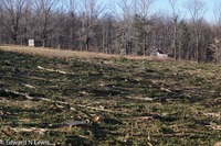
The spruce plantation has been removed using a 'feller buncher'. The logs have been removed from the site. The green needles on the ground will decompose. It will be necessary either to graze a few goats in the cut area, or plan to brush hog the…
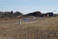
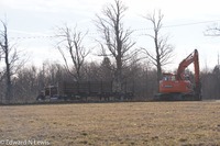
Logging Operation
End of logging operation converting woodland to grazable fields on the east side of SH-143.
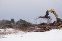
Logging spruce plantation

Logs are in queue for further processing. The picker is picking up clean boughs for chipping. The ships will be used to generate steam at Cooley Dickenson Hospital in Northampton.
Logging spruce plantation
The spruce plantation has been cut. The logs are queued for further processing. The pollards are stacked for chipping. These tree-tops are clean, they will be chipped for burning as bio-mass at the Cooley Dickenson Hospital in Northampton.
Our dog…
Our dog…
Logging spruce plantation
Spruce logs have been cut to length and loaded into a truck for transportation to a saw mill. These logs will be used for building a log cabin.
Logging with Horses - Earl Robinson, Dan Porter, David McEwan
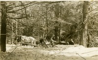
Black and white photographic post card of winter logging scene showing three men (Earl Robinson, Dan Porter, David McEwan) logging with a team of 2 horses. Identify Ted Porter. See also Joe Zeh logging DVD in Box 46.
Lois Ashe Brown at Post Office Event
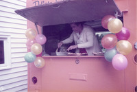
Post Office Open House. Lois Ashe Brown (1919-2000). .
Lois Ashe Brown typed article - West Worthington Church
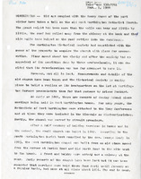
Typed article dated March 1, 1994 about the decay and fate of the West Worthington Church
Looking east from Pinebrook Farm (Albert Farm), Worthington Center
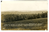
Sepia postcard from sample book of Herbert Berniss Thrasher (1884-1927), photographer. Title: "Looking East in the "Dear Old Berkshire Hills" from Pinebrook Farm, Worthington, Mass. (No. 9). Thrasher was the son of George M. and Hattie Lyman…
Looking Over the Rocky Be of Glendale Falls in a Dry Season
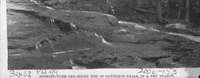
Black and white photograph of town common with Bartlett Hotel taken from book (Glendale Falls on back). Taken from General store. 'New Road' to Williamsburg from small common not yet constructed. White marker on common with Rice/Jensen house in…
Looking west from Worthington Inn
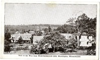
Black and white litho postcard, postally unused, white border on front. Shows 'View to the Wet from WORTHINGTON INN, Worthington, Massachusetts' Deforested Buffington Hill in distance. On back, written in ink 'Mrs. Zimmerman, Morristown' and…
Louis Dodge and June (Parish) Dodge
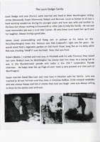
Brief account of the family of Louis Dodge and June Parish Dodge prepared for Worthington's 250th celebration. Menioned are James Dodge, Susan Dodge Morrison, Robert Dodge (wife Florence) and Norman Dodge. Also mentioned are Rob Cudworth and Ernest…
Lower School Children - Lyceum Hall?
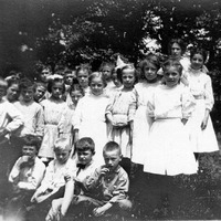
Children standing outside in warm weather, noted as 'Lower School'; girls in white dresses with hair bows, some boys with ties. Sepia photo scanned as black and white. Possibly Lyceum Hall
Lucie (Lucy) Mollison photo and obituary
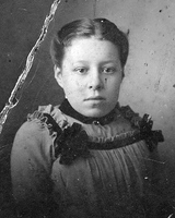
Black and white damaged formal portrait of Lucie (Lucy) Mollison (1899-1983). Found in the walls of Lucy (Lucie) Mollison's house. Also, obituary for Lucy Mollison from the Berkshire Eagle.
Lucy and George Osgood House
Lucy and George Osgood House. Many of these dryplate glass negatives are in The South Worthington Parish Book by Reverend George Reed Moody. Please see this book for further information. They were originally entered into the database with little…